
If you plan on traveling and camping on crown land in Canada, you will need to use the Land Use Atlas. This guide will take you step-by-step through the atlas and hopefully you will score a great site.
During our travels to southwestern US, our favourite camping experience was on public BLM (Bureau of Land Management) land. This type of camping is either free or very affordable. In most cases there are no amenities, which is fine by us as we are fairly self-contained in our campervan. We love it because usually you can avoid the crowds and enjoy a small piece of paradise in seclusion.
Call us antisocial. We don’t mind.
We didn’t encounter a lot of free camping in Ontario; is it because we didn’t know where to look? very possibly! There is an abundance of crown land (provincial or federal land) in Ontario, and in many cases you can camp in those areas for free. Some 87% of the province is Crown land and 95% of it is in northern Ontario and the numbers in other provinces are very similar. In Ontario, Canadian residents may camp in the same spot for up to 21 days for free, while non-residents will require a permit. There is more information here.
These sites are mostly boondocking, or dry camping spots with no amenities so you need to be self-sufficient. Please consider those who will camp there after you are gone and leave the site cleaner than you found it!
But how would you find where those areas are?
Google map doesn’t really give you this kind of information, and I couldn’t find any app dedicated to Ontario crown land. Naturally, we were very excited when we found online tools that will let you extract this information for most areas in Canada.
Because our next trip will be to Northern Ontario, we will concentrate on finding camping spots on Ontario crown land using the Land Use Atlas here. Scroll to the bottom of the post for links to information for other provinces.
Using the Atlas
The atlas is not easy to use at first glance, so we are including below a step-by-step guide to extracting the relevant information. Try it a few times and you will get the hang of it fairly quickly! It doesn’t work well on phones, it works a little better on tablets, but it is best used on a computer. You will need cell/internet reception to use the atlas when travelling, so it may be a good idea to print sections of the map with some notes ahead of your travel.
Once you log in and accept the terms of use, you have an overview of the entire area that will be covered.

It may be easier to consult a physical map that shows crown land, then pull out your area of interest. You will quickly realize that the majority of crown land in north of Lake Simcoe. We use Backroads Mapbook.
First let’s take a look at how the different land use options are displayed on the map:
Click on Map Layers and then click Legend on the bar below it . The legend will appear on the left-hand side of the screen.
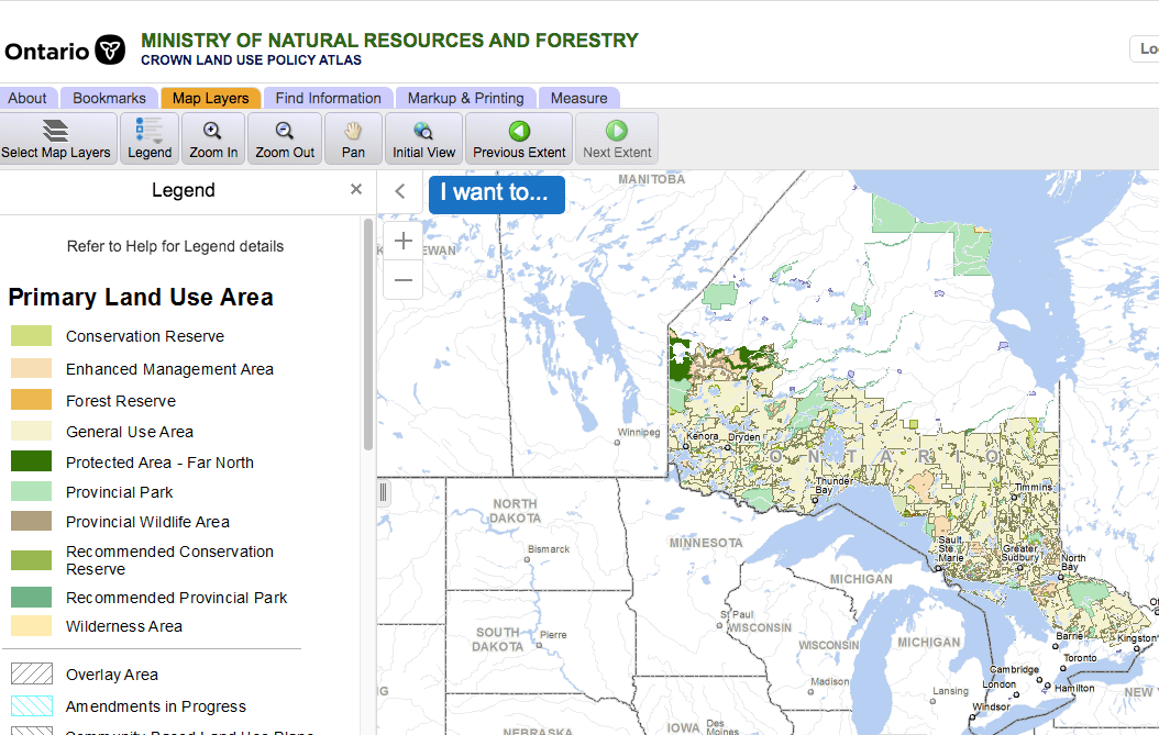
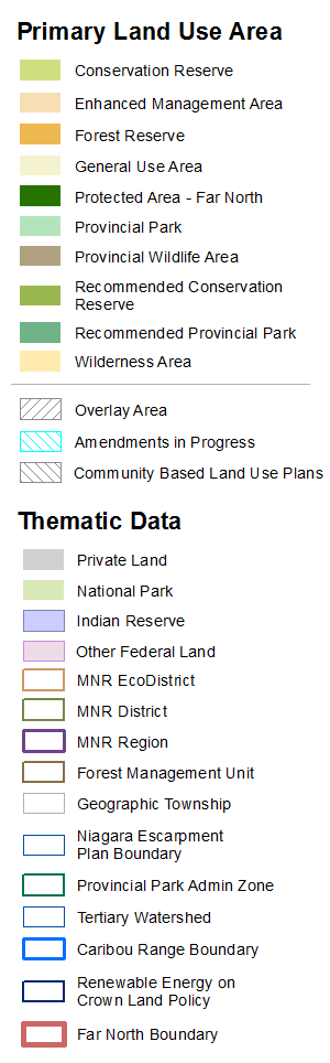
Below is the full legend. It may be useful to print as a hard copy for quick reference. The first 10 areas are where you may be able to find locations that allow camping. This may be in the form of free camping, or in one of the parks’ developed campgrounds. At the bottom, under Thematic Data you will find the grey area, which indicates private property. This is an example of an area to avoid.
extracting LAND USE Data
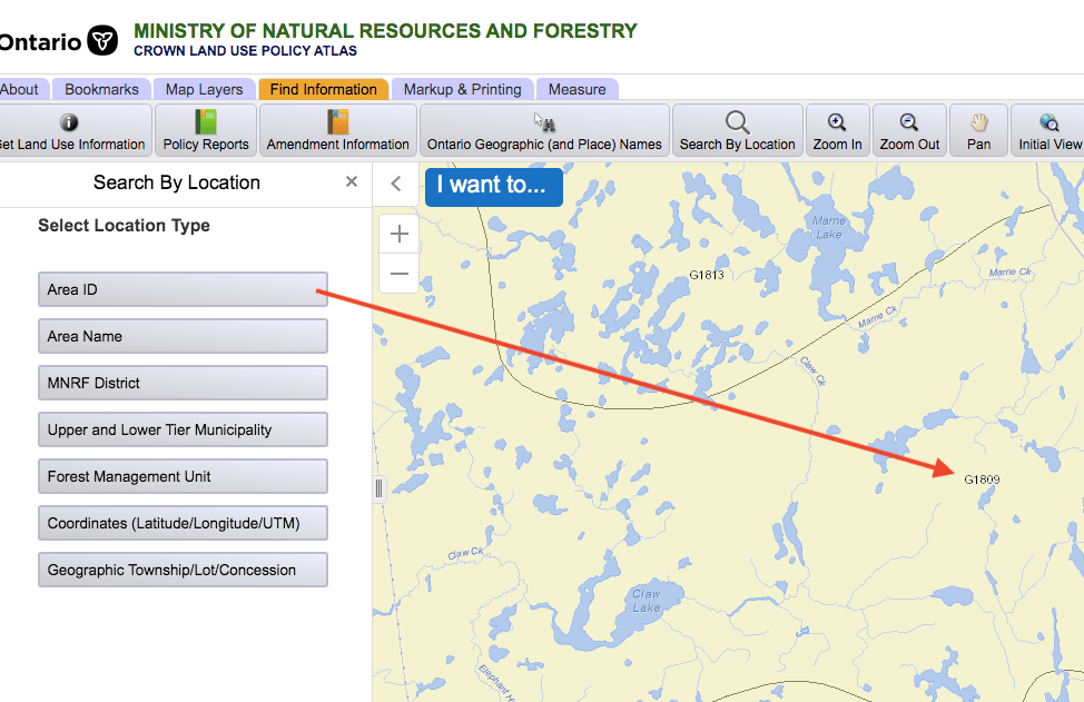
To drill further into the data you have several options:

Option 1: type in a name of a town or a park and press enter. The map will zoom in to the centre of the desired area.
Option 2: here you can choose other search perimeters: Area ID, Area Name, MNRF (Ministry of Natural Resources) district, Upper and Lower Tier Municipality, Forest management Unit, Coordinates, Geographic Township Lot/Concession. If you have this information, you may find it easier to search this way. To find the Area ID on the map you need to zoom in until the number appears (shown below).
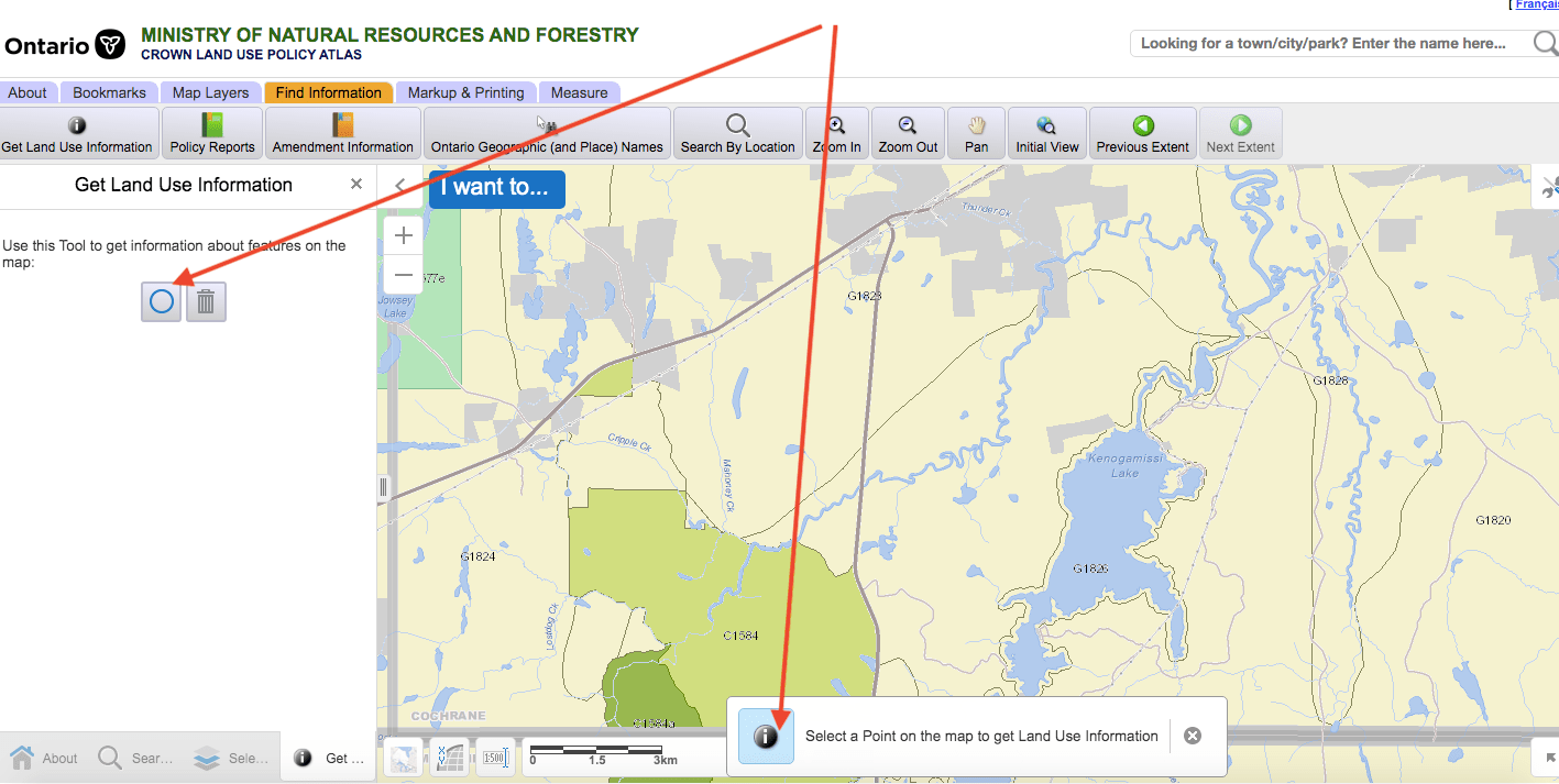
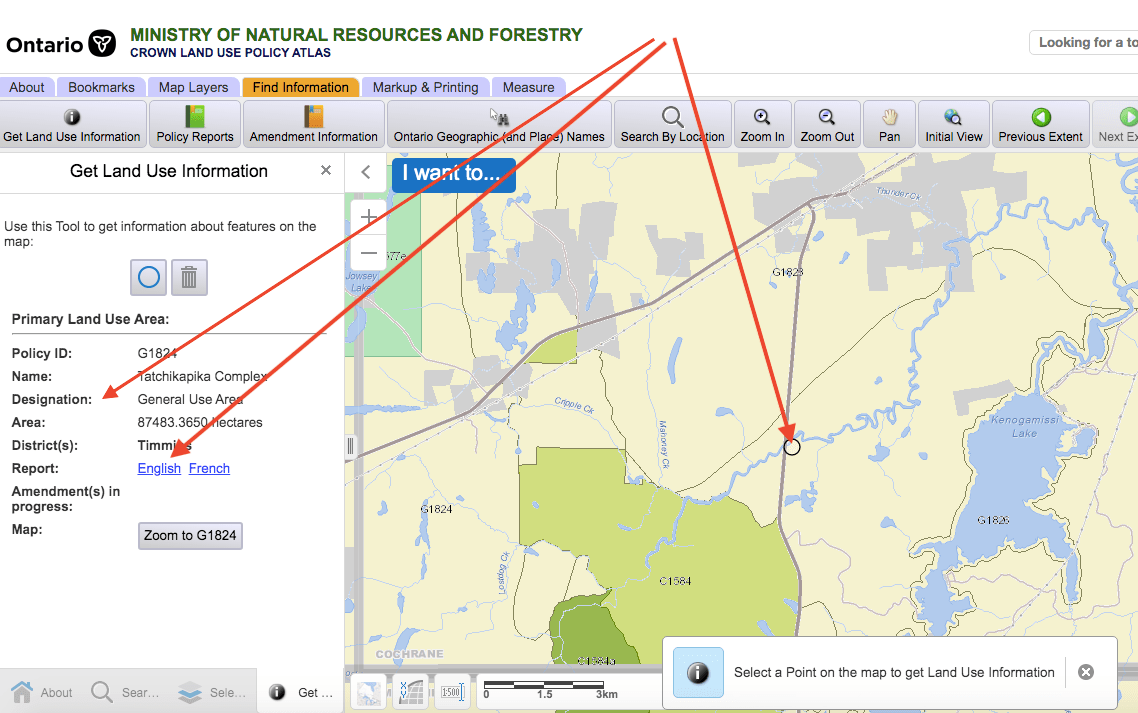
Option 3: I prefer this option since you simply need to click on your point of interest.
Land use data analysis
Once you click on a specific point (the small circle), a new menu will appear on the left (see below).
First take a look at the Land Use designation. In this case the designated is General Use.
Next, Select either English or French and a land use report with more information will pop up.
The first part of the report includes general information pertaining to land use, geology, geography and more. Depending on the actual location, it can be short, or very detailed. Scrolling down the document you find management information, that in most cases, will not be relevant to camping.
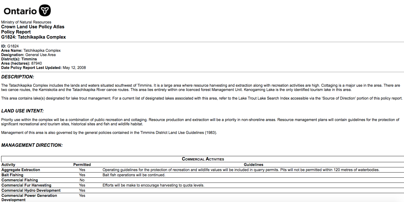
So scroll to the end of the report and you will find under Recreation Activities and Facilities the relevant data.
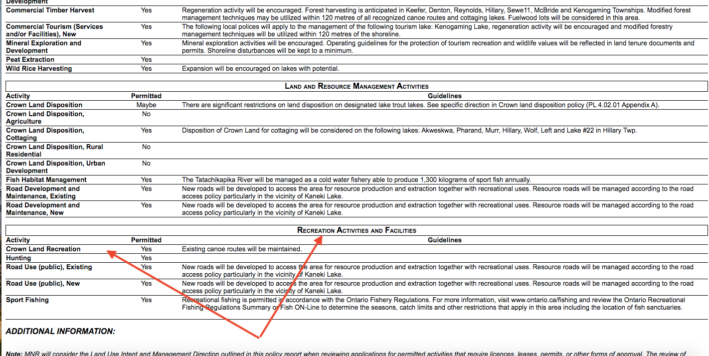
but can you camp there?
In the example above there is no mention of camping, however, it doesn’t explicitly say that camping is not allowed. Information for some areas states that camping is allowed. Some identify a campground on site. Others that current land use will be continued (without specifying what it actually is). There is even a “Maybe” category. I will call to the Ministry of Natural Resources to see if I can get some clarifications on this. For now though, we will treat these areas as open for camping unless it states otherwise.
Canadian Provinces and TERRITORIES Crown LAnd Maps
Canada-wide Wall Maps you can either find one large map for the entire country, or individual PDF files for the provinces and territories.
Alberta this land use atlas is similar to the Ontario one.
British Columbia this land use atlas is similar. Here is a great training guide
Saskatchewan this land use atlas is similar to the Ontario one.
Manitoba this is the best resource that I could find for Manitoba. Let us know if you know of any other maps and we’ll update the link.
Quebec the map seems to have a French version only. Please let us know if you know of an English version.
New Brunswick this is an interactive map, but different than the Ontario example.
Nova Scotia this is an interactive map, but different than the Ontario example.
PEI there doesn’t seem to be an interactive map for PEI. instead, you can click on a area and download a PDF with the information. Please let us know if you know of an interactive online map for this province.
Newfoundland this map is interactive, but different than the Ontario example.
Yukon this land use atlas is similar to the Ontario one.
Northwest Territories this land use atlas is similar to the one demonstrated above.
Nunavut this map is interactive, but is different than the Ontario example.
Feel free to include additional information in the comments, or if you are shy, send us a message through the Contact Us page. You can find additional information about finding campsites in Ontario here.
If you enjoyed this post, please follow us. You can like our Facebook page, share on your favourite social media page, or drop us a line to tell us about your experiences. When you shop via our links to Amazon.com in the United States, or in Canada at Amazon.ca we will get a portion of the sales.
Very, very useful. Thanks!
Thanks,! Glad you found it useful!
as an american, i can’t visit canada at the moment, but love knowing this is out there when the borders open once again and it is safe –
Hopefully this will be over soon and we can all move freely and safely again! I didn’t get into how to get a permit for non-residents. Maybe once the borders open up again I can dedicate a post to that!
Such a useful guide, and so well explained in terms of how to take full advantage of such a resource. Happy boondocking!
Thanks, Jim! Look, you are even using the word boondocking in a sentence 🙂
Always have my trusty Atlas in my vehicle every time we travel. Am very good at using it too. It definitely is an important tool when one is venturing around America and Canada.
We hope to make it across the border someday. We love our U.S. Atlas, good to know there is one for Canada, too! Thanks for information!
Thanks! I hope we all be able to resume our travels including border crossings!
I can imagine the stories that will be told! Can’t wait ????
I will try to not disappoint 🙂
anyone one have great spots to share in ontario? im new to this!
Most people will not share the spots that they are finding. There are many reasons to this, but mostly it is because they are afraid that others will spoil it for them. You can try and follow the instructions above to identify potential spots in the area that you are interested in, but then you will need to to do the leg work yourself.
Wonderful information for those close enough to explore the outdoors. Good for you!
Thanks so much! We are so lucky to have these vast wilderness areas in Ontario!
Certainly a useful post for people in Ontario. Anything that helps people get through these difficult times is worthwhile. Good for you.
Thanks! It was a bit frustrating to use the atlas at first, which is what prompted us to write this guide. I hope it helps. It is applicable to moset atlases in all of the provinces and territories.
When I last traveled through Ontario, I went on the theory that if camping wasn’t prohibited, I could do it – and plead ignorance if questioned. We stayed at a boat launch, didn’t get off the water until dark, and left it cleaner than we found it. (Much!)
This is generally true, especially when municipal properties are in question. If there is a sign that clearly states no overnight parking, it’s a good idea to stay clear, if not, you are usually okay. Crown land, which is usually provincial may have some prohibiting rules associated with no signs. For example, distance from roadways. I would hate being asked to move in the middle of the night, especially after drinking a couple of glasses of wine 🙂 My favourite are staying on wharves and municipal docks and going down to the beach in the morning>
It sounds brilliant…camping on Crown Land..especially bringing kayaks along.
Yes, kayaking or canoeing away from the crowds is an extra bonus! Thanks for stopping by!
YW!
Lots of great detail!
Thank you! I hope it will come useful in your travels!