
There are several beautiful and interesting parks in Sarnia and one of them is the Point Lands Park. I’m sure we’ll be back here in the summer for longer walks and maybe for a tasty lobster roll on the docks, but on this cold fall day we came to see the Dow Working Scale Model of the Great Lakes.

Above is the view from a viewing platform towards the Great Lakes model, and below is the view from the platform towards the St. Clair River.

In the diagram below, you can see the difference in elevation and depth between the lakes, which were replicated in the model.

Below is a Google satellite image of the model, which it looks pretty accurate!
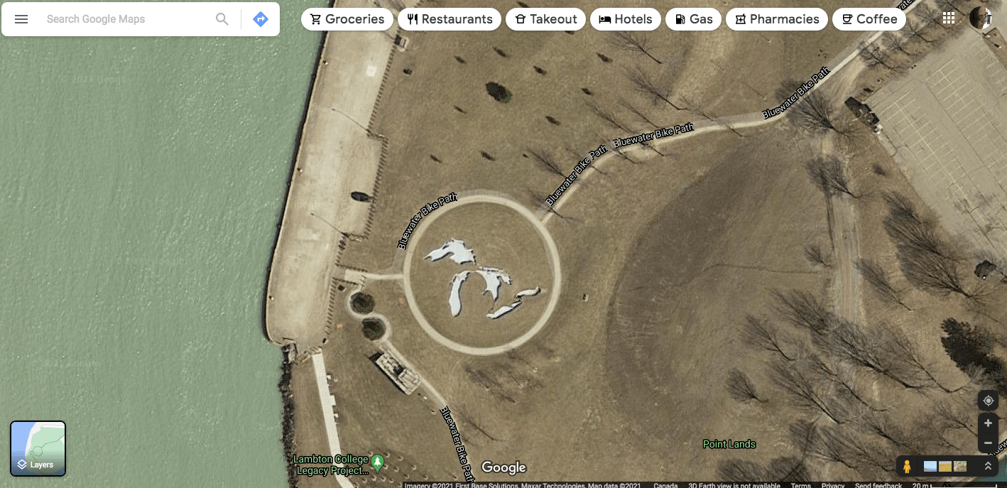
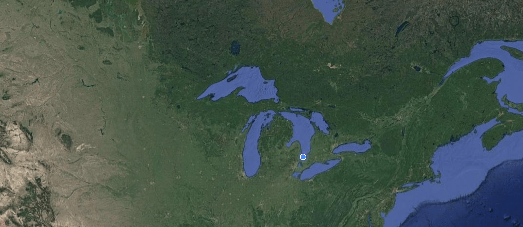
Here are the image of the actual Great Lakes on Google Maps. Very similar!
Below are several images of the empty basins.

It was actually interesting to walk around and try and identify some of the familiar features, such as Niagara Falls,

or Manitoulin Island.

We can’t wait to come back in the spring when the basins are full of water!
There are other things to see in the park.
Art installations.


This water access does not seem to have a purpose, but it does.


It serves as a scattering site and was made to accommodate the growing Hindu population in Sarnia. That’s very inclusive!

There are trails and gazebos along the St. Clair River.


It was starting to rain, so we headed back to the car.

One more glance towards the model.

We definitely need to come back here when the model is up and running with water. Hey, summer is just around the corner!
I also can’t wait until you go back when the model is full of water. It’s very cool. I want to see those photos. It’s also very cool and progressive that they created the scattering site. Sarnia looks and sounds like a nice place to live.
So far this place is exceeding our expectations! There is a sense of community and a lot of kindness is being spread around. It is a more conservative place than we would have liked and we have liked, so initially we had some concerns, but so far, so good!
that would be an interesting place to visit. I never realized that Niagara Falls was connected to the Great Lakes.
I liked the title of your blog, as I am sure C.S. Lewis would also!
Haha, thanks! As I replied below, one of the hostages came up with this and I am making full use of the idea!
I would have done the same thing!
I love the play on words and literary reference in your post title! ????
Sarnia is a place I hope to visit one day and this park with the Great Lakes model looks cool. You had me sold at lobster roll! ????
Haha, one of the hostages suggested it a while ago and I am taking full advantage of his genius 🙂 Let me know if you’re ever coming down this way, maybe we can have this lobster roll together 🙂
Will do! ????
Enjoyed reading your post. This looks like a wonderful place to revisit during warmer weather.
It is. I am looking forward to seeing it full of water!
????
Such a great place. I really like the Great Lakes Profile chart. It will be nice to see it with water. But is your visit recent? Green grass???? If you have that now you’re killing me???? Maggie
We visited in late fall, but I have to say that our grass is snow-free and and brownish-green right now. Not complaining 🙂
jealous! We have a lot of snow, although we are spending most of our time in the mountains.
So far it’s been consistently about 4c over the rest of ontario. Tomorrow we’re expecting 15c! The mountains sound nice though 🙂
Such a unique idea.. 🙂
It is!
Wow I love that! This would be great to see both full of water and empty as you show in your pictures. Your play on words is fantastic.
I will report back once these basins are full of glistening water!
I love the model because it helps us to compare the lakes in a visual way the way words wouldn’t allow.
I agree! It is one thing to look at a map, and another to be able to walk around these features and understand a little better how they are connected.
That is very interesting. I never stop to consider how different the lakes are under all that water!! And you are eternally hopeful-like me ????
I am hopeful 🙂 You described this perfectly — we don’t really consider the shape of things when they are under water!
Oh my, the model of the lakes is brilliant. Every middle school teacher in the world should have a link to this for every class. All the other was interesting but the old teacher in me is stuck on the lakes.
I thought so too! Brilliant idea and so teachable!
That model is so cool, and a neat way to raise questions and teach geography. I never gave thought to, let alone know, what bodies of water Niagara Falls was attached to until now, for example.
It is a wonderful way to teach Geography, and other environmental lessons. I would love to see this expanded to show the outline of the ancient seas that covered a much larger area around these lakes, but I am not quite sure that the park is big enough 🙂
“THE CHRONICLES OF SARNIA”, brilliant idea! I like this replica of the Great Lakes, I was dreaming of driving around them, now I can do it on foot.
Thanks 🙂 And your idea is also brilliant!
The model of the Great Lakes is pretty neat. They aren’t called the Great Lakes for nothing. I knew Lake Erie was the shallowest of the Great Lakes, but didn’t realize it was that shallow in comparison to the others.
That’s likely why it’s warmer than the others, but also because it’s the southernmost of them all. I thought it was a pretty cool model.
Beautiful photos as always, even in the rain. You are skilled photographers for sure. Cheers, Muriel
Thank you ❤️
Love the title of this post! I looked up Sarnia on Maps and now I understand why the interest and information about the Great Lakes is so appropriate there. Interesting and educational, and nicely designed.
Thank you! Yes, the Great Lakes theme is very relevant to our lives right now. We love finding out little bits of information about the lakes and beaches around us.
Interesting!
Thank you!
One of the most interesting things I’ve read tonight. It is truly amazing how important the Great Lakes are to us. A model that shows the depth and importance of the Lakes is something I would want to see. Thanks for sharing! Your photos are great!
Thank so much for your kind words! I hope you get to swing by Sarnia one day and take a look at the model first hand!
Me too.
Beautifull park! Geology and landscape evolution of the Great Lakes should be commented in the schools of Sarnya and other canadian cities. These lakes have a glaciogenic origin, they were “excaveted” by many rivers of ice during the Pleistocene epoch, before 11 thousand years ago.
Yes, they are important and interesting and hopefully this model is included in local schools field trips!